 Home
Ultra
Calendar
Past Events
Join
History
Where to Run
Home
Ultra
Calendar
Past Events
Join
History
Where to Run

If you are a new runner, new to Ridgecrest, or just visiting our area, you might be wondering where to run. Here are a few ideas to get you started exploring our roads and trails. For most of the routes we suggest, we will provide a course map and a description. In many cases, there will also be a link to view the course on one or more online applications. You can use the phone version of the application to navigate the course, or you can download a .gpx file to upload to another navigation application. Learn more about some of the navigation applications.
If you want to be able to just start out from your home or wherever you are staying, Ridgecrest is a pretty safe place to run. Our streets are laid out on a grid with major streets every half mile, so it's easy to map out a course of any distance.
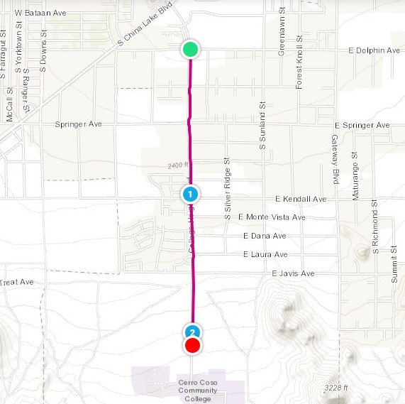
We have two paved bike paths. One follows College Heights Blvd., starting at Dolphin, just south of Walmart, and going south, gradually uphill, about 2 miles, almost to the college. Parking is available on the southeast corner at Dolphin and at Springer. You can also park near the top of the trail.
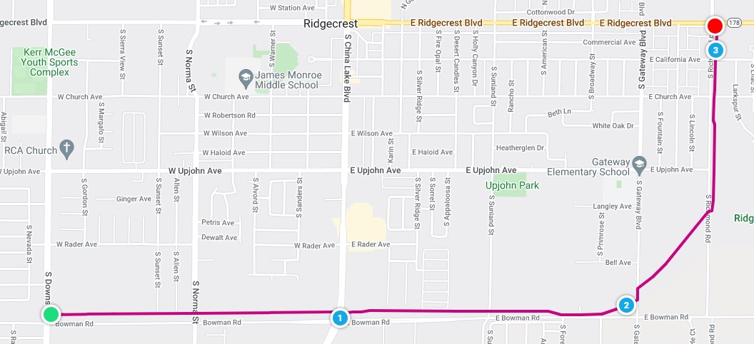
The other path runs along the north side of Bowman Road, starting at Downs. When you reach Gateway, at about 2 miles, you will need to follow Gateway north for a short distance before picking up the trail again on the east side. At Richmond Rd. cross again to follow the trail north to E. Ridgecrest Blvd/Hwy 178. You should be able to park north of Bowman Rd. near where the trail intersects Downs or Norma.
If you are up for running on dirt roads and trails, we would like to introduce you to our backyard! BLM lands south of Ridgecrest offer a multitude of opportunities for off-road running and hiking, in an area known as Rademacher Hills. Several trailheads provide access to this region, as shown in the map below.
Enjoy our local flora and fauna! In years when winter rains have been plentiful, our desert can produce awesome spring wildflower displays. Depending on the season, you might encounter jackrabbits, various species of lizards, maybe a desert tortoise, or even hear coyotes yipping. We do have snakes, some of which are poisonous, so be alert, especially when temperatures range between 80 and 90 degrees F. Please also be on the lookout for and yield to other trail users, including mountain bike riders, equestrians and hikers.
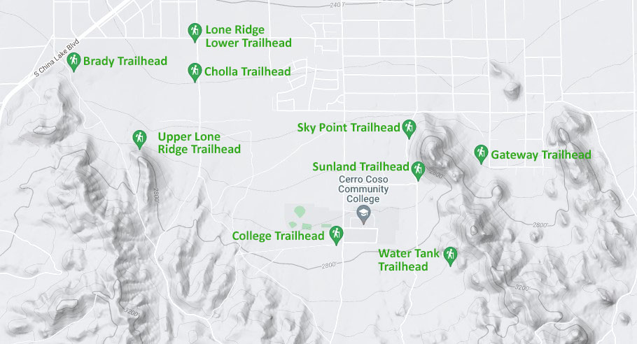
The trails described in this article are organized in groups, by trailhead or trailhead region. The College Trailhead is the start for many of our club races and fun runs. To the east, Sky Point, Sunland, Watertank and Gateway Trailheads provide access to a network of trails on the ridge east of the college. To the west, Lower Lone Ridge, Cholla, or upper Lone Ridge Trailhead will get you to the start of the Lone Ridge Trail, and Brady Trailhead provides access to the trails on White Star Ridge. Select the link on the left to skip to the region you want to learn more about. Several route suggestions are provided for each region. Click on the course name in the provided table to access a course description page. Many of the course description pages are repurposed from one of our Summer Challenge trail running virtual series. You can find all of the past Summer Challenge routes here. Most include a link to the route in one or more online applications.
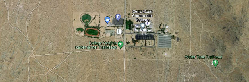
And a track...Slightly unrelated but worth mentioning, there is a nice track at the college, as you can see from the satellite view map below. The gate to the athletic complex is on the northeast side of the green area surrounding the track. Parking on the college campus requires a permit, so do your warmup by jogging from the College Trailhead parking lot. Go back down the hill to the gym parking lot on your left and head west.
A note about safety. Running off-pavement presents a different set of safety concerns than running on the roads. Dirt jeep roads and single-track trails can present tripping hazards, so stay alert to the running surface. During the hot summer months, run early in the day if possible, and carry plenty of water. If you are not accustomed to running in the heat, adapt on shorter runs. Again, watch for mountain bike riders, who may be traveling at a high rate of speed if traveling downhill. At some times of the year, sidewinders and Mojave Green rattlesnakes may be out and about, so keep an eye on the terrain ahead of you.
If running alone, it's a good idea to let someone know where you have gone and when you expect to return. You can also use an app like Garmin Connect to allow someone to monitor your position with its LiveTrack capability.
The College Trailhead is the most central and most easily accessible. Reach it by going south on College Heights Blvd., until the end of the pavement at the south end of the college. Park in the dirt parking area on the right.
There are almost infinitely many possibilities for putting together a running route beginning at this trailhead. A few are offered in the table below. Click on the course name to go to a page with a course map and more information. Distance and elevation gain are approximate.
| Course Name | Distance, mi. | Elevation Gain, ft. |
|---|---|---|
| Back to School | 2 | 203 |
| Firecracker 4000 | 2.7 | 321 |
| Bike Trail Loop | 2.8 | 397 |
| Goldbug | 3.3 | 463 |
| Caballo | 5.1 | 760 |
These trailheads provide access to trails on the ridge east and northeast of the college. The Sky Point trailhead is best reached by turning left (east)from College Heights Blvd. onto Javis. Follow Javis east to Sunland, at the base of the ridge, then head south for a short distance. The Sunland Trailhead can be reached by continuing south. The best way to reach the Water Tank Trailhead is to continue a little past the College Trailhead on the dirt continuation of College Heights, then turn left at the fenceline. To get to the Gateway Trailhead, turn left onto Kendall from College Heights Blvd.(before reaching Javis). Follow Kendall to where the pavement ends at Richmond Road. Turn right to go south on Richmond to Javis, then turn back west to reach Gateway. Turn right and follow Gateway until it ends near the trailhead.
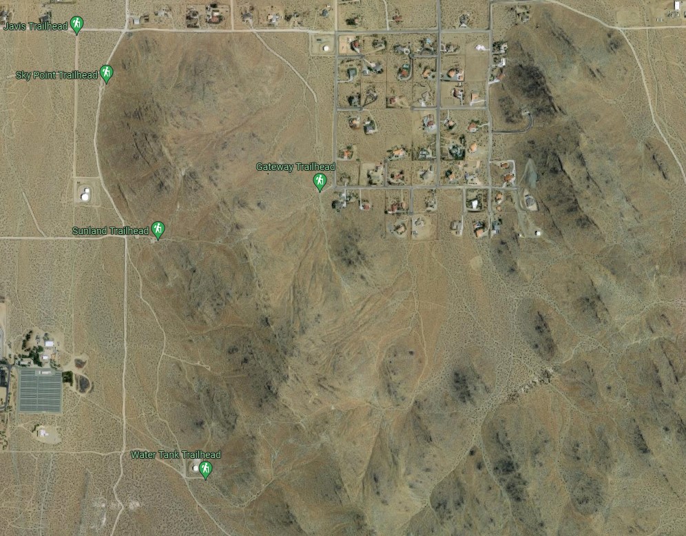
Click on the route name below for information on a few examples of routes starting from these trailheads. "Mikie's" goes straight up the ridge and follows the ridgetop for a ways. Andrews Peak follows lower trails alongside the ridge before ascending Andrews Peak. Sr. Discount is a version of a longer OTHTC event. The Sr. Discount name was due to having a few shortcuts for participants over the age of 50. This loop route can also be accessed from the Gateway Trailhead. A 3-mile option can be done, staying on the east side of the ridge. You can find it on Garmin Connect here. This one is our club's annual June Breakfast Run.
| Course Name | Distance, mi. | Elevation Gain, ft. |
|---|---|---|
| Mikie's | 3.9 | 1100 |
| Andrews Peak | 3.5 | 900 |
| Senior Discount | 4.5 | 700 |
All of these trailheads can be reached by going south on South China Lake Blvd./Business 395, and turning south onto Downs, right before a Shell station. Continue past the end of the pavement to reach Lower Lone Ridge Trailhead, then Cholla Trailhead. To get to the Upper Lone Ridge Trailhead, turn right at the first good dirt road south of Cholla Trailhead, then left in another quarter mile. Stay right at a Y, heading toward the nose of the ridge.
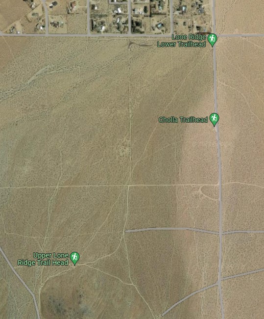
A popular trail in this area switchbacks up the nose of Lone Ridge. This trail is descibed, along with a few variations for returning to the trailhead, in the first table entry. Lone Ridge Plus is an example of how the climb can be extended, and Lone Ridge Loop encircles Lone Ridge, climbing another ridge to the south.
| Course Name | Distance, mi. | Elevation Gain, ft. |
|---|---|---|
| Lone Ridge | 1.2 | 325 |
| Lone Ridge Plus | 4.15 | 900 |
| Lone Ridge Loop | 4.15 | 700 |
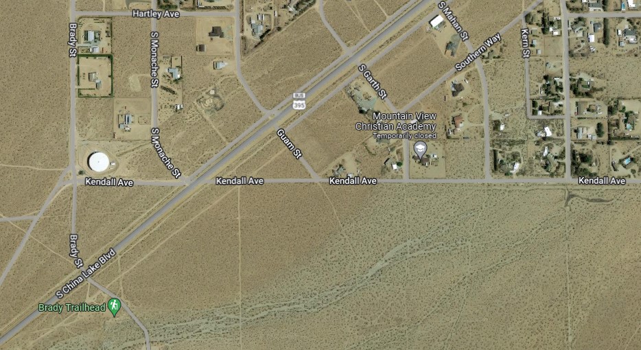
To get to Brady Trailhead, continue on South China Lake Blvd./Buniness 395 past the Shell Station. The turnoff to the trailhead is on the left, approximately opposite a large water tank on the right.
A few suggestions for exploring the area south of Brady Trailhead are listed in the table below. The Eureka mountain bike trail contours along the east side of White Star Ridge for about 3.2 miles. White Star Ridge follows the same trail at first, crossing over to the west side of the ridge and working its way to the top. The Adventure 5K provides an introduction to some additional territory on the west side of White Star Ridge.
| Course Name | Distance, mi. | Elevation Gain, ft. |
|---|---|---|
| White Star Eureka Trail | 6.2 | 1200 |
| White Star Ridge | 3.7 | 800 |
| White Star Adventure 5K | 3.1 | 500 |
OTHTC is a member of the Road Runners Club of America.