Andrews Peak
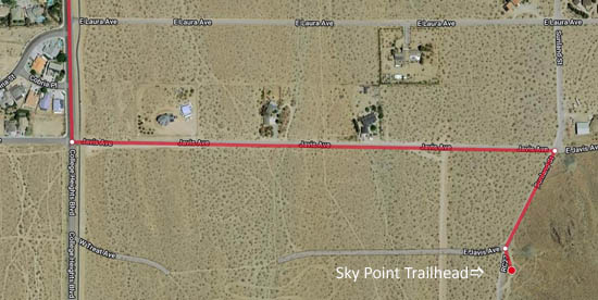
This course is an out and back route starting at the Sky Point trailhead, taking you to the top of Andrews Peak, the second big bump on the ridge to the east. Total distance is about 3.5 miles, with about 900 feet of elevation gain. To get to the trailhead, go out College Heights Blvd. and turn left on Javis. In about .5 miles, turn right on Sunland. The trailhead parking is about a tenth of a mile south, on the left.
The green buttons will take you to a Course page on Garmin Connect, or a Route on Strava or MapMyRun. If you need a .gpx file, you will be able to download that from any of these route pages. You can review the route navigation instructions here.
Course Description
Find the marked trail entrance at the south end of the parking lot. Head out the southbound trail paralleling the dirt road.
In about 0.4 miles, cross the Sunland Trailhead parking lot and pick up the trail on the other side, opposite the first parking area. Continue south, avoiding a branch that would take you back onto the road. About .75 miles from the start, you will reach a small parking lot with a picnic table. Turn downhill on the access road. You will pass an elaborate rail fence system on your left. This marks a steep wide trail. Don't go that way! Instead find a nice single track just past the west end of the rail fence, and go south on that trail, contouring around a hill.
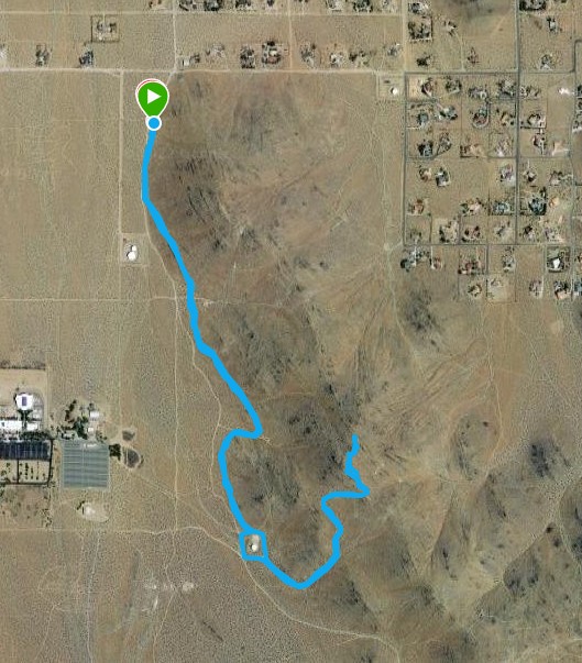
When you reach the water tank, follow the road around it on the left and head out the marked trail. Ignore trails cutting back to the left and stay in the wash until it becomes a road and tops out on the ridge. Go left on the ridgetop (Mikie's) trail and follow it to the top of the peak. Turn around and reverse your course back to the start, except now skirt the water tank on the other side.