Lone Ridge Loop
Course Developer: Wesley Elmore
This run begins and ends at the Upper Lone Ridge Trailhead at the base of Lone Ridge. It is an elongated loop that circles Lone Ridge. The distance is about 4.15 miles and elevation gain is about 700 feet. The route is on about half dirt road and half bike trail. Run the course clockwise.
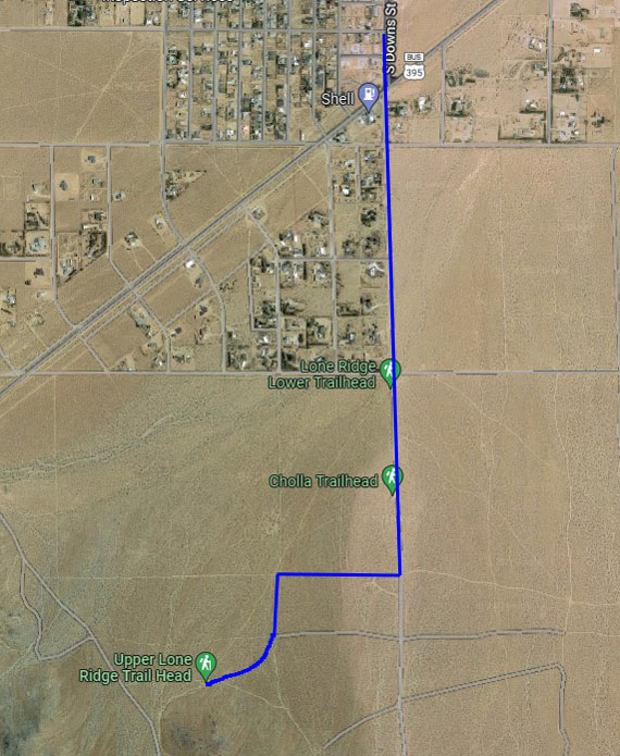
To get to the trailhead, turn south off S. China Lake Blvd. at Downs, and continue past the end of the pavement, passing Lower Lone Ridge and Cholla trailheads. Turn right at the first good dirt road south of Cholla Trailhead, then left in another quarter mile. Stay right at a Y, heading toward the nose of the ridge. Parking at this trailhead is limited, so there is the option of parking at one of the lower trailheads and warming up in getting to the route start.
The green buttons will take you to a Course page on Garmin Connect, or a Route on Strava or MapMyRun. If you need a .gpx file, you will be able to download that from any of these route pages. You can review the route navigation instructions here.
Course Description
Start on the road, near the bench by the trailhead sign, heading east. Take the first right, onto RC22. After a few hundred yards, bear right again. At about 0.33 miles from the start, go left at the fork, onto RC4.
At 0.53 miles, you will cross Downs road. Go straight, staying on RC4. At 0.62 miles, leave the road and take a bike trail on the left, going through wooden railings. At 0.78 miles, turn right onto a singletrack bike trail, heading south and uphill.
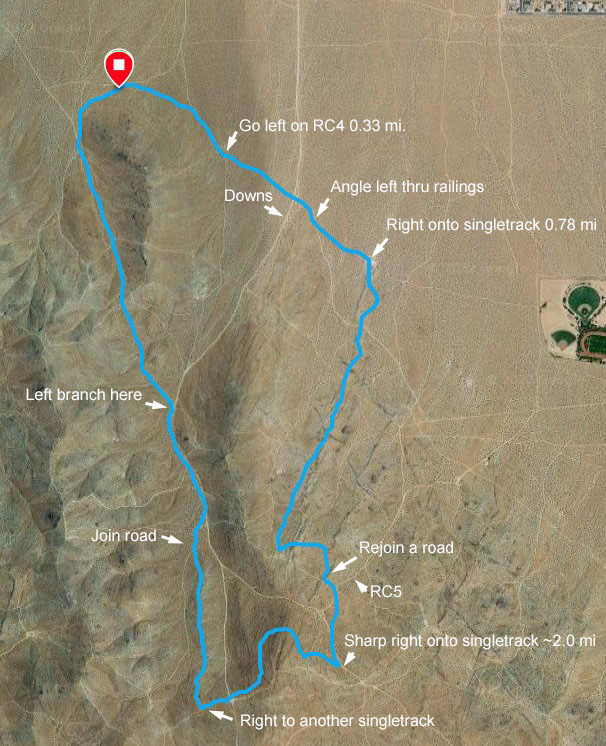
Cross over RC4 and several other roads, keeping on the bike trail and continuing uphill. When you near the top, the trail will curve to the left. You will be heading generally east as the trail winds across the hilltop through a rocky section. You will join up with a road heading east (1.8 miles). Stay on that road for a few yards. As you near an intersection with a well-traveled road (RC5), keep right to cut the corner then cross RC5 to take a left fork. (Note: For mountain bikers this section is on the classic bike course and is at the top of the hill known as "vomits".)
Join up with road RC72 reading south (uphill). About 2 miles into the course turn right onto a bike trail (Note: if you reach the top of the hill you have gone too far). Once on bike trail you will contour around the hill heading generally west. About 2.3 miles into the course the bike trail splits. Go straight. Do not turn right. About 2.45 miles into the course the bike trail will enter a road section. Cross over RC8 at the saddle, continuing west and uphill. Bear to the right as you go uphill. Do not take the bike trail which bears to the left.
At the top of the small rise, turn right and join up with a bike trail by a small rocky outcropping. You are now heading north on the bike trail as it goes down and along a small ridge. About 2.9 miles into the course join a sandy dirt road. Follow it downhill as it joins up with Downs road RC72, at about 3 miles into the course). From here until the finish you will remain on roads. Go downhill on the road.
About 3.3 miles into the course take left fork RC72. The next few hundred yards will undulate as you head up to the saddle south of Lone Ridge. Cross over the saddle and go downhill, staying on the road. After a few hundred yards veer right onto a road closed to vehicle traffic (look for stacked pile of rocks in middle of road). Go downhill curving to the right and back to the start point. The start point and finish point are the same. You made it!