Senior Discount Variation
This course starts and finishes at the Sunland Trailhead. That's the one just south of the Sky Point Trailhead, east of the college. If you are familiar with Eric Kajiwara's Sr. Discount course (longer option) this route is similar, without the trek from the college parking lot. Distance is around 4.5 miles. Run this one in a clockwise direction.
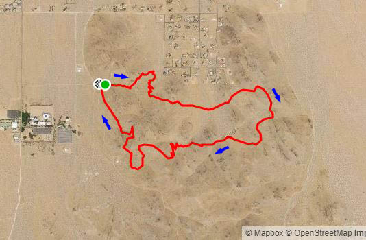
From the east end of the Sunland Trailhead, go straight up to the ridgetop, then head downhill toward the Gateway Trailhead at the southwest corner of the Belle Vista Estates. About 200 ft. from the trailhead parking area, turn on a trail that cuts back to the right, and begin to switchback uphill to the south. Continue south at a junction with a trail coming from the ridgeline, and reach a saddle almost due south of the Gateway Trailhead.
From here, work east across the broad valley above Belle Vista Estates, starting down a rock-lined trail. You will see a water tank at the SE corner of the development, and a black hill to the right of it. You will be traveling to the right of that black hill, up to the top of the ridge in the distance. Stay left at a few junctions, continuing east, and avoiding the opportunity to turn southeast, until almost reaching a road along the top.
Here, turn south/southeast. Cross a fairly well-traveled east-west road and continue south. When the road makes a 90-degree right turn, go that way. Continue WSW. Here is the most difficult part of the route to navigate, with numerous roads and trails in the area. Finally you will reach a well-defined trail that will take you on switchbacks back to the top of the main Mikie's
ridge.
Gain the ridgetop and merge onto the Mikie's
trail, heading north. Just before the trail steepens on the way to Andrews Peak, watch for a left turn, at a point where a more visible trail comes up from the east. Turn left to find a road going downhill on the west side. Follow that road downhill, west, then south.
As the road becomes less steep and becomes a sandy wash, look for a trail branching off to the right. Taking the trail, contour around to the west, then north, until reaching a saddle. Continue to contour around the hill and gently descend to a junction in a ravine. Take the trail that heads most directly north, slightly uphill, until it cuts back toward the ravine. Continue downhill, recrossing the ravine, and head for an unnamed trailhead. Cross the turnaround at the trailhead and take the lower of the two trails heading north from the turnaround, to return to Sunland Trailhead. At a Y, either branch will work.