Gold Bug
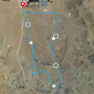
For this course, we will take you to a little bit of Indian Wells Valley history. The Gold Bug is one of the oldest mines in the Rademacher District, and was mined in the early 1900's and again during the depression in the 1930s. From what we can find, it was one of the more profitable ones in the area. Start and finish at the College Trailhead at the end of the College Heights Blvd. pavement. This clockwise route is about 3.35 miles long.
The green buttons will take you to a Course page on Garmin Connect, or a Route on Strava or MapMyRun. If you need a .gpx file, you will be able to download that from any of these route pages. You can review the route navigation instructions here.
Course Description
Head out the southbound trail at the east side of the parking area. Join College Heights Blvd and cross it at the fence south of the college, following the fence east.
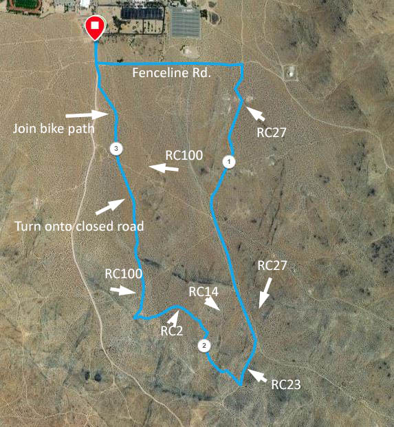
Circled numbers on the track are miles. Numbers RCnn refer to BLM signed routes.
At the east end of the fence, turn right onto signed RC27. You will also see signs Gldbug
and Sunlnd
. Continue south on RC27. Soon after the 1-mile point, RC27 will top a rise, curve slightly left, and begin to parallel another main road. When RC14 -- also signed Gldbug -- branches to the right at about 1.4 miles, keep left on RC27. We will approach the Goldbug area from a bit higher. At the next branch, about 1.6 miles, go right onto signed RC23. Then take the next right ( 1.8 miles) on a jeep road, uphill and passing through an opening in the fence. Go left a short distance to a more prominent road. Pause at the high point and enjoy the view. Cross the junction ahead and go up a rock-lined path.
From here, carefully go downhill to the next junction, signed RC2. Turn left and follow this road until reaching RC100. Turn right (downhill) here. Keep to this main road, ignoring the first few junctions. But further down, as RC100 curves to the right, keep left, on a closed road. Stay on that road, headed for the college, until you encounter the bike path angling left. Take the bike path back to College Heights Blvd and the parking lot.
Strava Route Issues
Just a few small issues I notice with the Strava route. They will probably not cause confusion. Just before 1 mile, the road splits and rejoins. The route appears to take the left fork and my track takes the right fork. Where RC14 goes right, Strava takes RC 14 for a short time before returning to RC27. Stay on RC27 here. Near the finish, Strava goes over to the bike trail before the intersection where you turn onto it.